Bulgarian
 Romanian
Early medieval fortress Kaleto, village of Izvornik

Overview
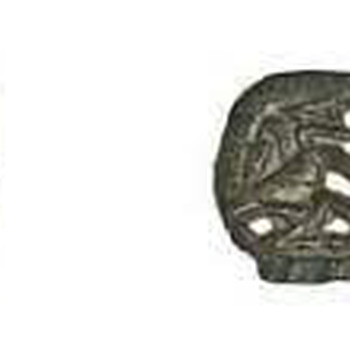
Thracian, ancient and medieval fortress called "Kaleto" is located in the area of the same name, 1.17 km south in a straight line from the center of the village of Izvornik. It is located in the low, on the left bank of a small river. To the north, east and south it is surrounded by a teardrop-shaped moat, which faces the sharp side to the west. It encloses an area of 35 decares. It is possible that this ditch from the west was connected to the river to fill with water from it, and it itself went around the western end of the fortress. In our opinion, the conclusion of R. Rashev and D. Rabovyanov that the river crossed the territory of the site is incorrect, because in this statement there is absolutely no meaning. South of the fortification in recent times the river is blocked to form a micro-dam, which includes the western part of the fortress. R. Rashev visited the fortress after the construction of this micro-dam and probably this misled him that the river passed through the site. And K. Shkorpil explicitly points out that there was no moat from the west, as the fortress wall ended above the river - "The walls were fortified with towers and a moat, with the exception of the western one, standing above the river." The fortification itself is not elliptical in shape, as R. Rashev writes, and the fortress wall has bends, and the fortress is really irregular in shape, dictated by the configuration of the terrain, as K. Shkorpil writes. This can be seen from a satellite image. In reality, without the western part, which has been destroyed, six walls can be seen. The outlines of 3 towers can also be seen - one round, outer in the east corner, one round or semicircular, outer in the south corner, and one larger, rectangular and outer on the northeast wall. The rectangular tower is approximately 35x15 m in size. The construction of the fortress wall is made of quarry stones, welded with clay according to R. Rashev. The total dimensions of the moat are approximately 277 m in the east-west direction and 174 m in the north-south direction in the widest eastern part of the site. The approximate dimensions of the fortress are 195x120 m. Inside, according to K. Shkorpil, relief plates of the Thracian horseman, Thracian and Roman coins were found. R. Rashev found pottery from the IX-X century, as well as belts, medieval ornaments from the same period. The ancient road that comes from the Roman city of Zaldapa from the northeast, which goes to the field of Pliska to the southwest, passes by the site. It is possible that there was a Roman road station here on the road in question.
Recommended
- Great Rock Protected Area
- Devnya springs
- Kalimantsi horse base
- Museum of mosaics
- Gradishte Rock Monastery
- Kara Cave Rock Monastery