Petrich Kale - Petrich Fortress
Overview
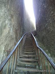
Petrich Kale is an early Byzantine and medieval Bulgarian fortress located east of the Beloslav village of Razdelna, Varna District. The fortress is located on a high stone terrace above the village of Razdelna, part of the Avren plateau. Its land is part of the Municipality of Avren. It can be reached through the village of Razdelna. At the end of the village continues on an unpaved road and a poorly marked tourist trail. Northeast of the fortress is a protected area Petricha, and on the way to it there is a tourist hut. A metal cross was erected and illuminated on the edge of the rock wreath on September 13, 2015. The cross is a sign of remembrance of the inhabitants of the village of Razdelna for the flood of February 1, 2015. The fortress was built in the 5th - 6th century as part of the early Byzantine defense system. During the period of the First Bulgarian State it probably ceased to function as a defense facility, and Slavic settlements were built in the land around it. Data on Petrich Kale are from 1154 by the Arab traveler and geographer Mohammed al-Idrisi. He describes the fortress as "a big, beautiful and rich city". During the years of Byzantine rule it functioned again, and during the Second Bulgarian State it flourished. It was conquered by the Ottomans in 1388. On November 7, 1444, the troops of the Varna Crusade reached the fortress of Petrich. According to sources, the Crusaders smashed the gates with cannons and demolished sections of the walls. Many people died in the assault, but the captured Hungarians and Slavs were released and sent to their native places across the Danube. It is believed that Bulgarian allies joined the Crusaders near Petrich. In the battles for the Petrich fortress, Philip Kalimach announced the military prowess of the Polish knight Lesko Bobzycki. The fortress was explored in the 1970s. They were resumed only in the second decade of the 21st century. According to historical data and modern finds, the Petrich fortress in the 15th century was surrounded by a triple wall, deep ditches and a steep rocky slope. Petrich is naturally protected from the west and north by sheer inaccessible rocks up to 35 meters high. To the east and partly to the south, the fortress is protected by deep steep ravines. It is accessible only from the south, through a narrow rocky strip connecting it with the Avren plateau. It had two rectangular towers measuring 11 by 9 meters, at a distance of 50 meters from each other, today preserved to a height of 7 meters. In another large tower, which defended the approach to the fortress, pottery and animal bones were found. There are remains of a wall on one of the towers of the fortress, 5-6 meters high. There are two preserved fortress walls of 5-6 meters. A small one-nave church was discovered, as well as graves around it. Residential buildings from the 11th to the 12th century are also known. An interesting landmark is a ladder dug into the rock with a length of about 20 meters. It leads to two huge water tanks with a capacity of over 700 m3. Various artifacts such as arrows, rings, coins, belts, jewelry, many iron objects were also discovered.
Recommended
- Zdravets Dam
- Petrich Kale
- Museum of Glass
- Camping Villa
- rock formation Pobiti Kamani("planted stones) (Dikilitash)
- Devnya springs
- Mosaic Museum
- Happy Land Amusement Park
- Eagle Stone (waterfall)


 Bulgarian
 Romanian
